- Conduct Wildfire Simulations
- Optimize Weather Stations
- Weather Station Application
- Open Source Materials
- Pilot Upper-Air Profiler
Authored by: Janice Coen, University of San Francisco & National Center for Atmospheric Research & Andreas F. Prein, National Center for Atmospheric Research
Accepted by: Journal of Geophysical Research: Atmosphere.
Prein, A. F., J Coen, A. Jaye. 2022. The Character and Changing Frequency of Extreme California Fire Weather. JGR Atmospheres Vol. 127, Issue 9.
https://agupubs.onlinelibrary.wiley.com/doi/10.1029/2021JD035350
As we’ve witnessed over the last several fire seasons, California is one of the world’s hotspots for extreme fire behavior. The state’s Mediterranean climate, characterized by wet winters and hot, dry summers, combines with the state’s complex topography and strong wind events, to produce conditions that enable rapid fire growth.
Work Group 1, the team within Pyregence focused on understanding the effects of historical weather on fire growth, recently completed an analysis of the state’s fire activity record. Records date back to the early 2000s (the approximate time workers began collecting intraday moderate resolution satellite active fire detection data).
To perform the analysis, team members used a novel machine-learning algorithm to identify archetypal weather conditions that were associated with the most rapidly growing fires during the last two decades.
The weather conditions identified include:
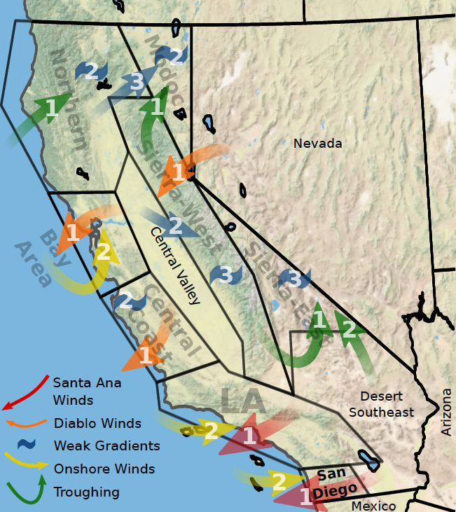
The algorithm was then applied to eight fire weather regions across California that have similar weather, topography, and vegetation. As featured in the map below, the fire weather regions included in the model were the four coastal regions (San Diego, Los Angeles, Central Coast, and the Bay Area), the western and the eastern faces of the Sierra Nevada Mountain range, the Northern coastal/central region, and a northern interior region.
Our research builds on the knowledge that fire behavior, as driven by weather, varies widely across regions of California, and is a function of human demographics, the built environment, climate, topography, fine-scale air circulations, and vegetation.
What our research yielded, is the idea that rapid fire growth is highly episodic, occurring only a few days per year. Days with the most fire growth are associated with two to three extreme weather types in each region that differ in their large-scale weather characteristics, have different seasonality, and produce distinct types of fire behavior.
For example, coastal regions feature two distinct extreme fire weather types. One is associated with strong and very dry offshore winds (Santa Anas in the south and Diablo winds in central and northern California) that occur most frequently in fall with a peak in October. The second extreme weather types were most frequent in late summer and feature a thermal low-pressure system that is associated with weak onshore winds, very hot and dry conditions, and plume driven fires that can be ignited by dry lightning.
The 2020 Napa Valley Shady Fire and the Bobcat Fire close to LA were associated with these two fire weather types, while the 2020 August Complex fire was related to an unrecognized weather pattern. In some areas, a third type of fire may be driven by local factors, not apparent in large-scale weather patterns.
Using extreme weather types allows us to better understand the driving mechanisms of extreme wildfires and predict upcoming hazardous weather patterns that have been associated with rapid fire growth.
While experience has shown that large, rapidly-spreading fires are frequently associated with offshore, downslope wind events in coastal areas and west-facing mountain slopes, the application of an objective analysis based on machine learning has other benefits and uses.
In addition to picking out wind events as an important weather type underlying large fires (confirming what we already knew), it picks out weather patterns underlying large daily fire growth in other regions where they are less obvious. Additional weather types associated with large daily fire growth in those regions plagued by downslope wind-associated fire events, for example, were identified. Once these weather types are identified for the regions, the analysis procedure can be applied to the historical weather record to examine how the frequency of some of the weather types may have changed over the past century.
Finally, the approach can be applied to climate simulations to estimate how they might change in the future.
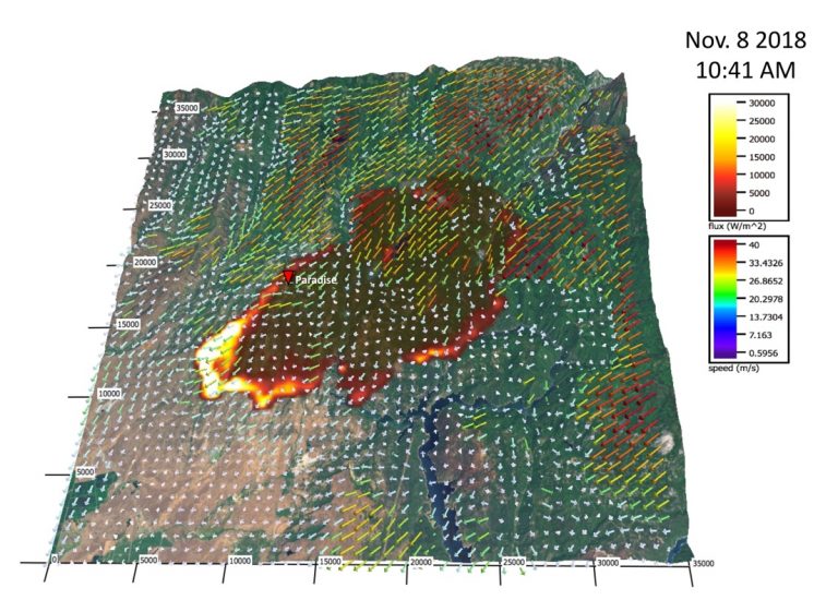
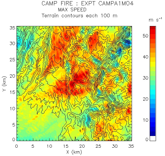
Regional analysis can be further refined by the use of “hyper-local coupled weather-fire modeling.” This modeling helps identify locations where combinations of atmospheric wind, temperature profile, and terrain shape produce local wind maxima and fast spreading fires.
Below is a snapshot of a coupled weather-fire simulation of the November 8, 2018 Camp Fire, and the maximum near surface wind speed produced during the day-long simulation, second by second. The preliminary findings showed the fire appeared to have originated and spread through a local high wind corridor.
The combined multi-scale approach illuminates critical weather conditions in each region responding to both wide-scale (synoptic) weather patterns and local micro-climates.