- Conduct Wildfire Simulations
- Optimize Weather Stations
- Weather Station Application
- Open Source Materials
- Pilot Upper-Air Profiler
Risk, in the simplest terms, is the possibility that something bad will happen. Wildfire risk is the possibility of fires causing harm—to human health and safety, buildings, power transmission systems, water supplies, natural ecosystems, and any number of other resources.
The degree of wildfire risk at any given location is determined by the interaction of a number of factors:
The likelihood that a fire will burn during a given year at a specific location.
For example, wildlands are more likely than cities to experience fires, and areas prone to high winds also have greater likelihood of fires.
The intensity of potential fires, as measured by how much heat is transferred.
Intensity depends on topography, available fuel, and weather. For example, a fire on a hillside filled with dead trees on a windy day is more intense than one involving grasses, flat ground, and calm winds. The more intense the fire, the more harm it can inflict. Both likelihood and intensity are determined based on fire behavior modeling.
The exposure of resources (homes, businesses, infrastructure, ecosystems, etc.) to wildfire.
Exposure is the physical proximity of an asset to potential fire. A home built in a forest is directly exposed to wildfire from flammable trees, while homes built further from wildlands face exposure from wind-blown embers or building-to-building ignition.
The susceptibility of a building or other asset to damage if a wildfire occurs.
A house with wooden shingles is more susceptible than one with composite shingles, and a bare wooden utility pole is more susceptible than one coated with fire retardant. Damage that occurs is directly related to intensity.
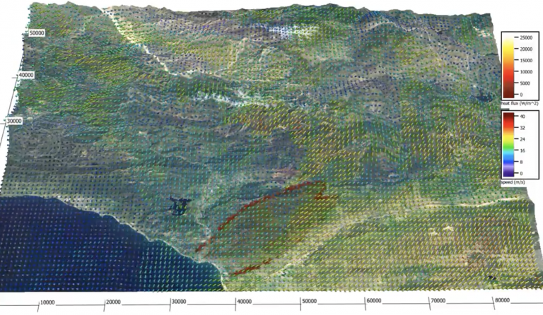
Wildfire behavior modeling predicts the probability of a fire being ignited, as well as how fast and in what direction it will move across the landscape once ignited. Fire behavior depends on an ignition source (lightning, a lit cigarette thrown out a car window, a downed power line, etc.), weather (especially wind, relative humidity, and temperature), the characteristics of the fuel (how much is available, how dry it is, its size), and topography (especially slope, because fire spreads more easily uphill).
In a wildfire behavior model, mathematical concepts and language are used to create millions of simulated fires based on patterns in weather, fuel, and fire behavior observed in past fire seasons. These simulations are used to determine the likelihood of fire occurring at a given location in a given year, and to forecast how currently active fires are likely to spread. These models are used by electric utilities, fire authorities, and land management agencies to assist in preparation, suppression, issuing of warnings, evacuation orders, and more.
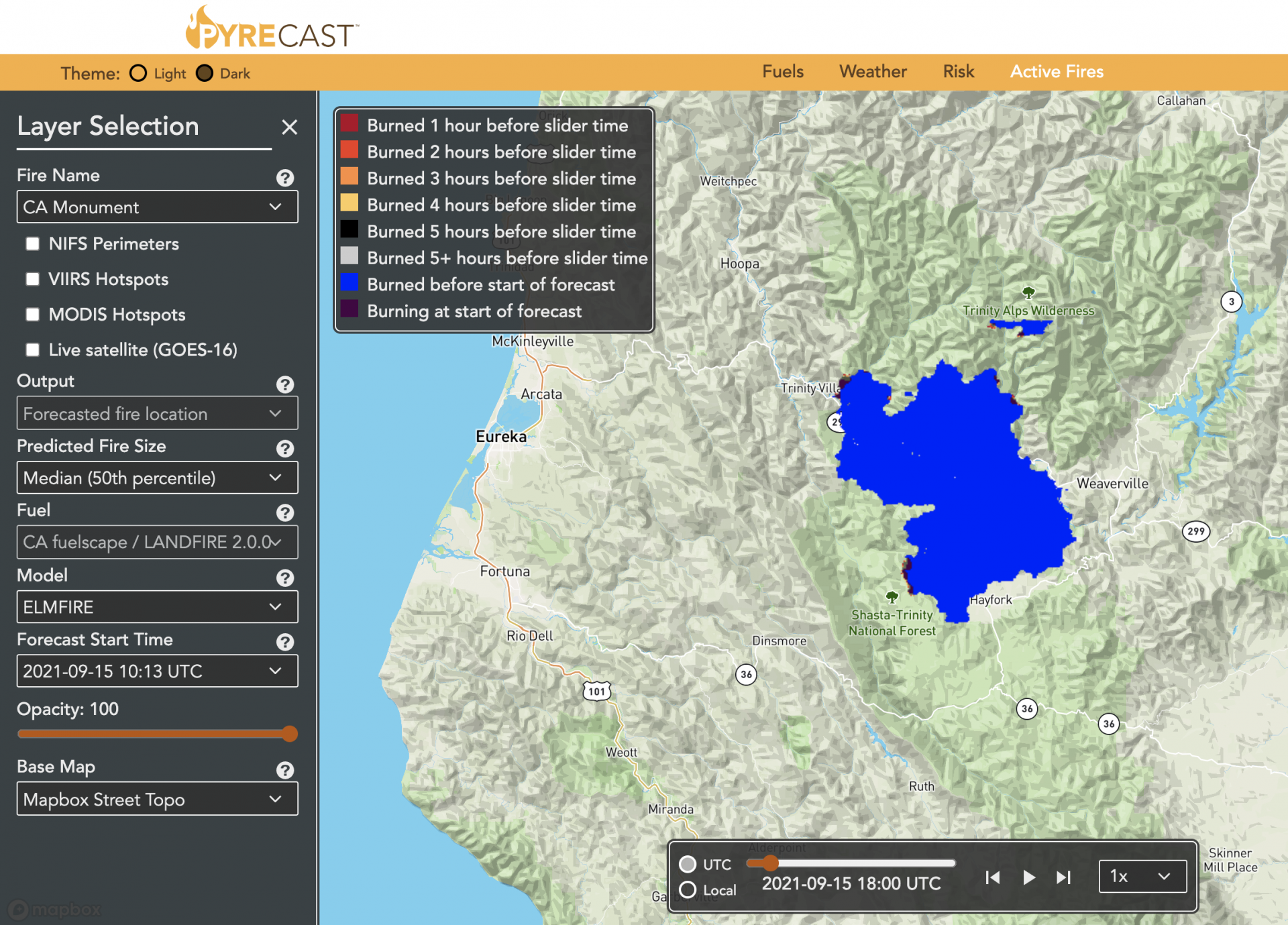
Wildfire risk modeling uses wildfire behavior modeling to assess how much damage potential wildfires could do to particular assets and resources. Risk models use computer simulations to predict fire ignition and spread and to quantify potential losses to assets such as electric utility infrastructure, water supplies, homes, businesses, and natural ecosystems—as well as human lives. When these potential losses are better understood through risk modeling, decision-makers can set priorities and take steps to reduce fire risks.
Electric utilities use risk modeling to assess and prioritize their work to improve the safety of the electrical grid. These steps may include:
Pre-treating utility poles to make them fire-resistant
Clearing vegetation around utility lines
installing stronger and more resilient poles to better withstand high winds
replacing bare power lines with stronger, insulated lines that are more resistant
Moving select lines underground to eliminate dangers posed by wind and trees, an expensive process that may be worthwhile in areas where risk is particularly high
Emergency managers and fire management agencies use risk modeling for a wide range of purposes, including:
Planning evacuation routes and, during fires, determining when to issue evacuation orders
Deciding how to manage wildland fuel loads through the use of controlled burns and mechanical treatments
Creating plans for wildfire response based on varying risks faced by different areas
Making decisions regarding when and where to deploy firefighting crews and undertake suppression efforts.
Policymakers, planners, and state and local government officialsuse risk modeling to mitigate fire risk in the long term by:
Requiring or incentivizing vegetation thinning and clearance and the removal of flammable materials from around structures
Writing building codes to require the use of fire-resistant shingles, siding, and decking materials
Encouraging housing development in low-risk urban areas and discouraging new construction in the wildland urban interface
Requiring risk reduction measures such as minimum street width, secondary access routes, and adequate water supplies in new developments
Encouraging agricultural lands, athletic fields, and recreational paths on the outskirts of cities to serve as firebreaks and buffers between wildland fires and developed areas
Determining a community’s risk profile for the purposes of insurance regulation
Assessing the public health threats posed by smoke emissions from wildfires
Developing strategies to recover from the emotional, financial, and ecological impacts of the wildfires that do occur
The public uses risk modeling to assess their own risks and take appropriate steps, which might include:
Creating defensible space around the home by clearing and thinning vegetation and moving log piles and propane tanks away from structures
Hardening structures with fire-resistant building materials
Creating emergency supply kits for both home and car
Buying an emergency radio or scanner to stay informed during emergencies
Creating family evacuation plans that include a variety of escape routes, a designated meeting location in a safe area, and provisions to evacuate pets and livestock.
Sign up for our newsletter to receive updates on the Pyregence project.