- Conduct Wildfire Simulations
- Optimize Weather Stations
- Weather Station Application
- Open Source Materials
- Pilot Upper-Air Profiler
In 2018 wildfires burned nearly 2 million acres in California, the most of any fire season up to that time. The record stood until 2020, when more than 4 million acres burned.
Even more alarming than the size of the fires, however, was their intensity. Historically, most wildfires have advanced at a slow, steady pace, burning leaves and twigs on the forest floor. That’s the type of fire that evolved as a natural part of California’s ecosystems.
Today’s fires, by contrast, spread with astonishing speed, and burn so hot they can generate their own weather systems. To find fires of similar intensity, you have to turn to the firestorms created by World War II bombing campaigns in cities like Dresden, Germany.
“The nature of fire is changing,” says David Saah, Principal Investigator for the Pyregence Project, a consortium of leading researchers from 18 institutions from academia, government, and private industry. “We’re bringing wildfire science and modeling up to date.”
Pyregence is creating next-generation models to forecast fire risk in the coming week—and for the rest of the century. Our scientists are pioneering new research into weather, fuels, and wildfire, and will feed this data into both near- and long-term risk models.
These innovative models will provide fast, accurate wildfire forecasts, ensuring that decision-makers have the critical information they need as quickly as possible. And our long-term models will provide a range of projections of wildfire risk in coming decades, allowing effective policy, planning, and risk mitigation.
“There are three things that can drive fire across the landscape: terrain, weather, and the amount and types of fuels on the ground,” Saah says.
Weather and fuel conditions have both seen significant shifts. Drought and insect infestations have left forests filled with millions of dead trees, potential fuel for the next wildfire. The climate, meanwhile, has grown hotter and drier, which dries out the fuels. Climate change has also led to an increase in the frequency of extreme weather that can drive fast-spreading fires.
The models used to forecast wildfire risk haven’t caught up with these new conditions.
“If you haven’t seen those configurations of fuel and weather before, they’re not going to be built into your model,” Saah says. “And if they’re not built into the model, you’re not going to be able to make accurate predictions.”
Pyregence has taken on a dual mission: first, conduct basic research to understand the climate and fuel conditions driving the new era of severe wildfires; and second, use the results of that research to help build the next generation of wildfire risk models.

This work is being conducted by teams of researchers devoted to four topics: Extreme Weather, Fuel Mapping & Fire Physics, Wildfire Forecasting, and Climate Change & Fire.
The Pyregence Extreme Weather team is working to identify the conditions that cause particular wildfires to grow quickly.
In a detailed analysis of select large fires from the past two decades, the team has identified a set of extreme weather types that are associated with rapid fire spread.
The team found that rapid fire growth occurs on only a few days each fire season and is associated with distinct types of extreme weather that occur in each of eight fire weather regions across California. If we can forecast when these dangerous weather conditions occur, we can take steps to prevent fires from igniting and to suppress them quickly if they do.
Making such forecasts will depend in part on access to better data, and the Extreme Weather Team is also working to enhance weather observations.
First, team members are identifying “blindspots” in California’s network of weather monitoring stations, where a lack of observing stations means there is insufficient information to accurately forecast fire weather conditions. This work will allow new weather stations to be sited where they are most critically needed.
The team will also conduct pilot tests of an upper-air profiler known as a sodar system, to determine whether measurements of upper-air winds will allow forecasters to anticipate the onset of surface winds associated with wildfires.
With better data, better forecasts should emerge.
“Understanding where we have gaps in knowledge is critical, especially in our changing climate environment,” Saah says. “You can’t respond to things you don’t know about.”
The same holds true for the fuels on the forest floor: we need more information about surface fuels in order to model how they will burn during wildfires.
The Pyregence Fuel Mapping & Fire Physics Team is conducting groundbreaking experiments to better understand the basic science of solid fuel combustion.
These tests are taking place in both small, laboratory-scale burn chambers and in a first-of-its-kind, large-scale burn chamber constructed from a grain bin roughly 50 feet high and 42 feet in diameter. In this chamber, scientists will be able to replicate the fuel beds in California forests, including large branches and logs. Sensors and scales will allow scientists to quantify emissions, heat release rates, and the transition from smoldering to flaming combustion.
The team is also projecting fuel loads over the next 10–20 years in areas where current tree mortality is at high levels, as well as creating a new system to measure and map fuel conditions through both field research and remote imagery (satellite imagery and lidar). The goal is to determine the properties of fuels—amount, size, depth—and to map how they are distributed across the landscape.
Together, these research projects will help us understand what types of fuels are on the forest floor, where they are located, and, if ignited, how they will burn under a variety of weather conditions.
“Characterizing surface fuels is difficult but crucial,” Saah says. “Pyregence has created a better methodology for integrating large-scale fuels into quantified surface fuel models. And that’s the linchpin of the new fire behavior models.”
Building better wildfire models is the core of the Pyregence mission.
A wildfire model is a software program based on sophisticated mathematical formulas and computer algorithms: you feed it information on weather, fuel, and terrain, and it predicts how those factors will interact to shape fire behavior. But a model is only as good as the underlying science and data, and most models currently in use are based on outdated information.
The Pyregence Wildfire Forecasting Team is creating next-generation forecasting models that will draw on the latest data on weather and fuel conditions. The models will incorporate higher-resolution inputs on vegetation and fuel, more frequent weather observations, and improved methods of predicting how active fires spread. Our new models are also computationally efficient, running in a fraction of the time required by past models.
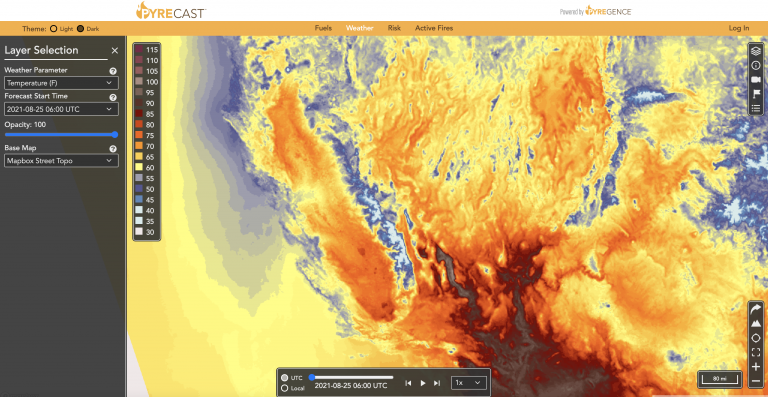
Beta versions of these models and tools, known as Pyrecast, are already publicly available through the Pyregence website.
Pyrecast includes three separate but related forecast tools. The first, “Fire Weather,” provides eight-day forecasts of key weather parameters affecting wildfire behavior (temperature, relative humidity, winds, precipitation, fire weather indices, and more).
The second, “Active Fire Forecast,” shows the locations of actively burning fires and provides forecasts of where they are projected to spread over the next three days.
The third, “Risk Forecast,” works by igniting hundreds of millions of hypothetical fires across the landscape and modeling their spread under forecast weather conditions over the next five days. This makes it possible to identify areas where rapidly spreading fires may occur, as well as areas at greatest risk of being burned by these possible future fires over the next several days.
Pyregence is bringing wildfire modeling up to date, and providing broad public access to wildfire risk and forecast tools.
“This information has never been made available to the public at the scale we've been able to deliver it,” Saah says. “These tools are brand new—and available to everybody.”
Near-term forecasts can help people assess risk and make immediate decisions regarding evacuation orders, suppression and containment strategies, public safety power shutoffs, and electric grid load management.
But longer-term risks must be addressed as well. California is preparing the state’s Fifth Climate Change Assessment, designed to analyze potential impacts from climate change and identify policies to protect the state. The Pyregence Climate Change and Fire Team is supporting the Fifth Assessment by developing models to simulate extreme wildfires through the end of the century.
Computer models can’t predict the future. What they can do is use the best available data to develop a range of scenarios—possible futures that might become reality, depending on the choices we make and the way the climate changes.
Compared to earlier efforts, Pyregence’s next-generation models incorporate more detailed input data on climate and weather, including previously unavailable variables such as wind speed, wind direction, and relative humidity. They also feature higher-resolution inputs and outputs related to fire risk and severity (including smoke-related illness), as well as improved data on landscape changes from development, fire, timber harvesting, and fuel management.
This modeling will facilitate the planning required to create a more resilient electric grid, improve land use and development policies, manage fuel loads through prescribed burns or mechanical treatments, and make a broad range of other strategic decisions. The goal is to protect California and strengthen the resilience of its people, natural systems, and infrastructure.
Just as important as the work Pyregence is doing, however, is the way the Consortium operates. Whereas much wildfire science is controlled by private companies, with the data and software hidden in a black box behind a paywall, Pyregence is committed to the principles of open science. All data will be made available, and all code will be open source when models and tools are complete.
“A collaborative approach is the only way to deal with the complexities of wildfire in a changing climate,” Saah says. “The goal is to get many different voices, and a wide variety of expertise, working together to solve these issues.”
Already, the open science model has proven its benefits—both within Pyregence and to the wider scientific community. Other organizations have used Pyregence research for projects as varied as energy pricing, evacuation planning, and evaluating the public health effects of wildfire smoke.
“The biggest surprise has been the hunger for this approach to work,” Saah says. “People say, ‘Hey, this is open? You’ll share stuff?’ Other scientific organizations, the private sector, government—everybody wants to participate.”