- Conduct Wildfire Simulations
- Optimize Weather Stations
- Weather Station Application
- Open Source Materials
- Pilot Upper-Air Profiler
![]() The Weather tab provides eight-day forecasts, updated every six hours, of key weather parameters affecting wildfire behavior (temperature, relative humidity, winds, fire weather indices, etc.).
The Weather tab provides eight-day forecasts, updated every six hours, of key weather parameters affecting wildfire behavior (temperature, relative humidity, winds, fire weather indices, etc.).
![]() The Active Fires tool shows the locations of actively burning fires as identified through satellite-based heat detection and provides forecasts of where they are projected to spread over the next three days, much like a hurricane track forecast.
The Active Fires tool shows the locations of actively burning fires as identified through satellite-based heat detection and provides forecasts of where they are projected to spread over the next three days, much like a hurricane track forecast.
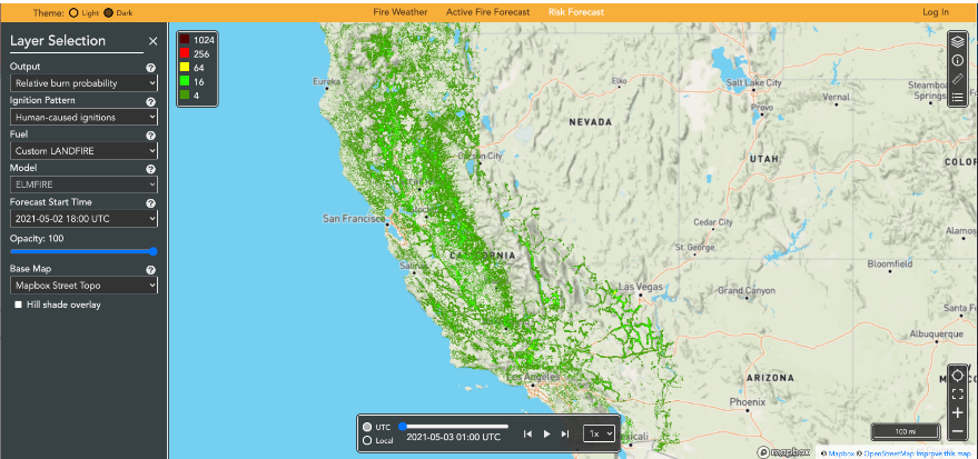
![]() The Risk tool works by igniting hundreds of millions of hypothetical fires across the landscape and modeling their spread under forecast weather conditions over the next five days. This makes it possible to identify areas where rapidly spreading fires may occur. Hypothetical fires are also ignited near powerlines to help utilities decide where to shut off power to avoid sparking fires, although these forecasts are proprietary and therefore not publicly available.
The Risk tool works by igniting hundreds of millions of hypothetical fires across the landscape and modeling their spread under forecast weather conditions over the next five days. This makes it possible to identify areas where rapidly spreading fires may occur. Hypothetical fires are also ignited near powerlines to help utilities decide where to shut off power to avoid sparking fires, although these forecasts are proprietary and therefore not publicly available.